


Whittington
First recorded in the Domesday Book as ‘Witetune’ and in 1212 as ‘Witington’.
It comes from the Old English (Anglo-Saxon) and means the ‘tun’ of the people of Hwīta. Hwīta was an Anglo-Saxon name and the ‘ing’ is short for ‘ingas’ or ‘people of’. A ‘tun’ of course was a larger settlement, possibly with an administrative function. These ‘ington’ place-names seem to have appeared after around 760.
It is very likely that Whittington had an administrative function because in 1066 it was the centre of an important lordship. It had been owned by King Harold’s brother, Tostig, the Northumbrian Earl, but by Domesday was under the King. A small motte still exists to the west side of the church. The lordship consisted of nearby Newton, Thirnby, Arkholme, Gressingham, Hutton Roof, Cantsfield, Ireby, Burrow, Leck, Burton-in-Lonsdale, Barnoldswick, Ingleton, Casterton, Barbon and Sedbergh.
The lordship controlled key strategic routeways. It helped to control the Lune Valley from around Gressingham to Barbon and the routes alongside the River Greta and the Leck Beck. These rivers and roads connected the Lune Valley with the ancient ‘Aire Gap’ route across the Pennines – now roughly the A65.
With a lordship of this size it is very likely that the parish church already existed. It is again a parish with a single township, which in this part of the world, indicates its prosperity and its likely early importance.
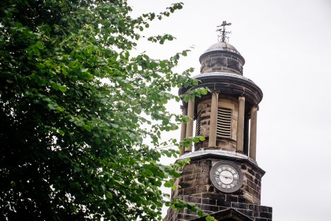
The image shows Whittington church, strategically sitting on the edge of the rise that overlooks the main road and the flat land down to the River Lune. Next to it on the left is the slight rise that is the remains of the Norman castle motte.