


Cantsfield
Cantsfield was recorded in the Domesday Book as ‘Cantesfelt’. It is a real rarity in this part of the world as the Old English ‘feld’ originally meant ‘open country’. The same word can be seen cropping up in the Dutch ‘veld’.
‘Field’ names in England are generally thought to date from the 500s and 600s. Since it is thought that the Anglo-Saxons only started to settle in this part of the world in the 600s, it is perhaps at this time that Cantsfield was named. Only from the late 900s did the meaning start to change to arable land, reflecting changes in farming practices and the break-up of the larger estates to smaller townships and parishes.
The first part of the name ‘Cant’ has been the subject of discussion. The favoured suggestion these days is that it is named after the Cant beck and that ‘Cant’ was a British (Celtic) name. Many of our local river names are British in origin due to the probable survival of British lordship in this area until around the 600s.
The other suggestion is that it is a personal name – and this was the favoured option back in 1922 when Ekwall wrote his book on the ‘Place-names of Lancashire’. Ekwall felt that it might be a shortened form of the Anglo-Saxon name Centwine and that the river was named after the place (as is felt happened with the River Wenning).
The area in the upper Lune Valley which includes Cantsfield seems to have been significant in the early medieval period. For the nature of the area there are a large number of single township parishes. Lancashire was so sparsely populated that this is why there are usually many townships to a parish as they had to be able to afford a priest and a church.
As has already been mentioned there was an important Domesday lordship of Whittington – which included Cantsfield. The area also includes the Roman fort at Burrow and was on the route through to Settle and the ‘Aire Gap’ routeacross the Pennines.
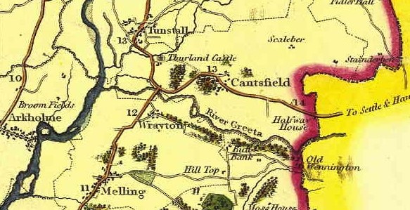
The map is taken from Greenwood’s map of Lancashire of 1818. The full map can be found here https://www3.lancashire.gov.uk/environment/oldmap/greenwood/greenwood.asp